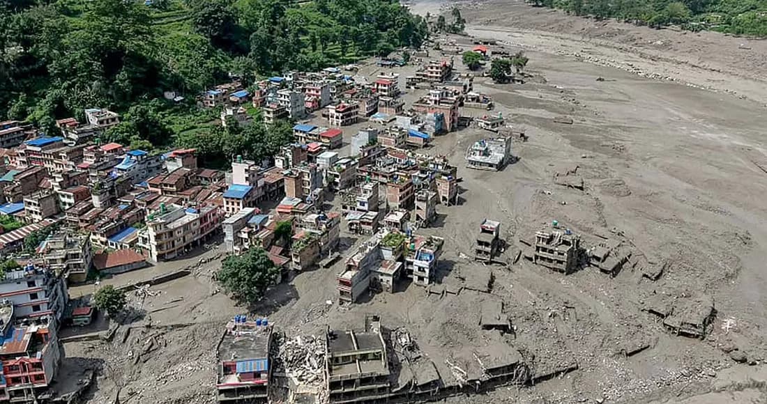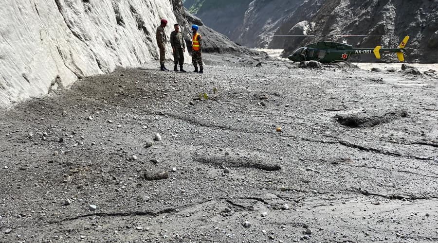
Perhaps something that hasn't come up in public circles yet (or maybe I haven't even heard of it), but now its importance is even more apparent, so this article is written focusing on the scientific monitoring that can be done from the sky in the Himalayan region of Nepal. Nepal should start launching regional satellites within a few years on its own initiative or in collaboration with other countries to monitor mountain changes.
The satellite that is going to be discussed here is not a cheap and learning satellite that Nast made for a student project some time ago, it is a satellite with real capabilities. However, I do not mean to denigrate Nast's satellites and the work of those involved. One such satellite, whose data was used around the world in the current flood of Rasuwa.
And most importantly, Manuchehar Sirzai, a professor at the Virginia Tech University in the United States, using satellite images taken from January 8 to August 19, made public, based on preliminary analysis, that there had been movement or deviation in the ground months before the snow-rock landslide in Rasuwa. According to him, the results of his preliminary analysis show that the ground in the area is moving at a rate of 10 mm per month.
His analysis further illustrates the importance of such satellites. Moreover, it costs a lot to make such a 'geostationary' (stable in the same orbit with the motion of the earth) satellite; My initial estimate is around $200 to $500 million. This amount is the same amount as the MCC grant given by America to Nepal.
However, this one-time investment can be fruitful for Nepal compared to the amount of damage caused by floods like the current one. Again, many other things can be done with such satellite images, not just monitoring the mountains.
If Nepal wants, it can ask for money from various sources and start the work. A few years ago, India launched a similar satellite with the help of NASA.
We have seen in this flood that the early warning system currently installed in Nepal is limited. Therefore, such satellite-based monitoring is necessary. And, based on that, an early warning system can be made; Which is useful not only for the early warning of such large flood events, but also for monitoring and preparedness.
The current early warning system in Nepal usually sends information to the center that the water has risen or crossed the danger level based on a certain amount of water rising in the sensors placed on the surface of the river. The center sends an SMS to the phones connected through the mobile tower of the respective place and people take precautionary measures after receiving the same notification.
But satellite monitoring, especially radar-based satellites (which can see the Earth's surface even under clouds and at night and are called active sensors), can help detect subtle variations in the ground. Often satellites require sunlight and are obscured by clouds when taking pictures. In the case of Nepal, there are more floods and landslides in this season and the sky is covered with clouds at that time, so such a radar-based satellite is more useful. This is the reason why we don't get cloud-free satellite images now.
Using radar satellite images with sensors that can penetrate such clouds and reach the surface of the ground, as Professor Sirzai did, it is possible to see the movement of the ground surface of a place. Often before a landslide or an avalanche occurs, there is a deflection in the ground at that location, and then the landslide goes away.
But importantly, glaciers are dynamic in nature and change in size with the seasons as the amount of snow melts and freezes. Since the time-lapse images taken by such satellites on different dates also show that the change is 'moving', it is difficult to say that the land has moved in terms of landslides. But there are different methods of distinguishing whether the deviation of the glacier is due to landslides or natural, which are now gradually being used. can be distinguished from it.
The data obtained by organizations such as ISIMOD that 47 glaciers in Nepal are in danger of bursting are also measured using satellite images taken at different times.
Therefore, we can constantly monitor the dangers of glaciers or other causes in our Himalayan regions from the sky. And, we can place more sensors or cameras in high-risk areas that are identified as a threat based on ground deviations from aerial surveillance and analysis. We can make a system to send SMS immediately if there is a risk of landslide or rupture. In this way we can not only forewarn, but anticipate danger.
The method of monitoring the glacier by placing a camera near it has also been used in Nepal. Around 2012, Ulyana Nadia Horodeski, a PhD researcher at the University of Colorado, set up a camera to monitor Nepal's glaciers. Journalist Prem Baniyan promoted it on television as a 'spy camera' in the program 'PowerNews'. After his popular program, the matter started in Nepali media, 'Pipli Live'.
I refuted it and wrote an article on the 'Mysansar' blog saying that it was not a spy camera but kept for research. After the misleading news was published, I contacted the scholar and informed him about the situation in Nepal. Then she appealed to various agencies and the dispute was resolved. The issue was also discussed in the international media, the incident was even made news by "Scientific American".
Well, this context means that by placing such cameras where there are glaciers, we can continuously monitor glaciers or glaciers that are considered more dangerous, and that technology is currently being used.
It is not that the current early warning system does not work at all. Although recent floods in Nepal have increased, it seems that this system has contributed to the decrease in the number of human casualties (according to the statistics I have seen).
Even in this year's flood, due to early warning (not that it should be played on the mobile phone, because of the news in the media, etc.), although there was material damage below Trishuli, there was no human loss. That is not to say that it is not important; But at the level where damage and danger have started to increase, its use is limited, so it is necessary to shift our efforts to satellite-based monitoring.
In addition, disasters are now cascading. That is, an avalanche or a landslide occurs, a lake forms or a river gets dammed and bursts, and then it creates more trouble. Our preparedness to deal with such 'cascading' disasters must be correspondingly multifaceted.
Not only to put satellites in the sky, but also to create a 'center of excellence' for remote sensing and geographical studies in Nepal. For that, instead of creating a central research institute which is currently being created under the Ministry of Science, Technology and Innovation, it is appropriate for Minister Mahavir to go back to creating a similar specialized research center.
Otherwise, after the establishment of an institution under that ministry, the current NAST will end up fighting over who will do scientific research as to who is the 'apex body' in Nepal. I guessed that after seeing/hearing the tussle between the Ministry of Education, Science and NAST for the past few years. Which is a common trend among our different organizations doing similar work.
Therefore, it is right to create a specialized organization like 'Center of Excellence' for Remote Sensing and Geographical Studies in Nepal under the Ministry; Because such satellite monitoring is also a matter related to the country's strategic security. In the future, if it expands, an organization like NASA of America or ISRO of India may or may be created.
Moreover, we are now talking about claiming 'loss and damage' due to the rapid melting of snow in the Himalayan region due to climate change and causing such floods. For that matter, governments around the world have created a 'Loss and Damage Fund' or a 'Climate Damage Compensation Fund' after COP-27 of the United Nations Framework Convention on Climate Change (UNFCCC). In order for us or any other victim country to receive compensation for such events from that fund, we must scientifically prove that the event is caused by climate change, and only compensation will be received.
For that reason, the government has now written a letter to the Loss and Damage Fund established in COP-27 of the United Nations Framework Convention on Climate Change (UNFCCC). Writing a letter is a good thing, it gets international attention.
In particular, some of the world's media are now trying to present this flood as a normal natural phenomenon that occurs over time in mountain ranges like the Himalayas, rather than the effect of climate change. So the letter gives more strength to climate justice.
However, what the government needs to understand is that writing letters like this does not earn money. Just like the government can't give money based on someone's application saying 'I have suffered a loss, give me compensation', it says to go through different procedures. In order to get compensation in this way, the process, necessary documents and evidence must be collected.
But if the intention of the government is to melt the heart and put the Dipo, I think it would have been better if it had made a public appeal rather than the 'Loss and Damage Fund'. We will write a letter to him after providing the process and evidence. But if it is written, it will promote well.
As for what this phenomenon has to do with climate change, I looked at the temperature rise data for that region and found that the temperature for the summer months (June to August) is now about 3 degrees Celsius higher than it was in 1940. This was not extracted and analyzed by me, it was taken from the 'X' account of climate scientist Robert Rhode of the organization called 'Berkeley Earth'. Because he and his organization are credible, his statistics and analysis appear to be close to fact.
In addition, another graph he put up shows that the number of days with glacial melt, i.e. the number of days when the temperature needed to melt snow is above zero degrees, has also increased significantly in recent years.
He has also published the daily temperature data for August 2024, 2025 and 2026. Although temperatures were higher in all three years at that location, the temperature increase in August 2026 is abnormally high.
But this available analysis is based on data from 'ERA Five/Climate Data'. We have also used this data in many research papers. It is now the most widely used data source worldwide for the study of climate change.
But it has its limitations. Since its grid resolution is 11 km, in a geography like Nepal where the average temperature drops by 6 degrees Celsius for every 1,000 meters of elevation from the southern Terai to the northern Himalayas, this data shows the same temperature from base to peak within that 11 km room; Which is not compatible with our hilly and mountainous terrain, even if it is compatible with Terai. Also, we have very few climate measuring stations. So in a complex geography like ours, that data may not be that useful. But we are working on creating useful statistics.
That is why our organization Global Institute for Interdisciplinary Studies is working on 'downscaling' of the said 'ERA5/Climate Data'. That is - converting 11 km resolution grid or room data into 1 km room, using machine learning or AI.
But the problem is, the daily data of the 50th year is again 1 km resolution of the raster grid of Nepal (which can be of the size of a GB for one day) and cannot be analyzed by a normal computer, it needs a powerful computer.
So since our local computer capacity is not enough, we are doing it by paying a fee to Amazon or AWS supercomputer. All of the analysis codes have been written and tested, and the analysis on Amazon's servers has started just a few days ago. We are doing this work 'even if it is by eating corn-soybeans' rather than anyone's help, because we know how much its value and importance is for a country like Nepal where data is limited but necessary.
Ironically, we had to buy the data measured at the real meteorological center to 'trend' the required downscaling of the data from the Department of Hydrology and Meteorology. Which we also bought. What to do, this is the case in Nepal - we have to buy the data collected by the organization that is maintained by paying our own taxes to use it for public benefit!
But now satellite companies around the world have provided free data worth millions of rupees for Nepal. By using it by people all over the world, we now know roughly what happened. Such statistics have also been used in many media of Nepal. This is the importance and power of free data or open source.
If everything goes well, in a few months we will publish a research paper with the results of the work mentioned above. Once that work is done, we will be able to make many important findings and people will reuse them in many types of research in Nepal on climate change. I believe that will go a long way in filling the lack of climate data here.
So in conclusion, Nepal has a lot of work to do. The resources are very less, even the available resources are being spent without distinguishing which is the primary subject. Now let's work towards it without delay.
Until we scientifically explore the basics of disaster forecasting, reliable and trustworthy methods of hazard measurement, and the causes of disasters, we will continue to be mere 'paper experts' who talk big about theory. This is the right time to start the foundation work.
Shrestha, who graduated in environmental science from the US, is interested in researching contemporary issues, especially science-technology, policy, environment and human relations. Photographs of Shoukhin Shrestha have received national and international awards.